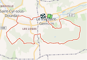
2017-05-10 Rando Le Val St Germain

jchezlemas
User

Length
12.7 km

Max alt
164 m

Uphill gradient
240 m
Km-Effort
15.9 km

Min alt
73 m

Downhill gradient
241 m
Boucle
Yes
Creation date :
2017-05-10 00:00:00.0
Updated on :
2017-05-10 00:00:00.0
3h24
Difficulty : Easy

FREE GPS app for hiking
 SityTrail
IGN / Geographical institutes
SityTrail Plus
The world is yours!
About
Trail Walking of 12.7 km to be discovered at Ile-de-France, Essonne, Le Val-Saint-Germain. This trail is proposed by jchezlemas.
Description
Rando de Martine et Alain Gauthier
Office de Tourisme de l'Arpajonnais
http://ot-arpajonnais.fr/
Positioning
Country:
France
Region :
Ile-de-France
Department/Province :
Essonne
Municipality :
Le Val-Saint-Germain
Location:
Unknown
Start:(Dec)
Start:(UTM)
430666 ; 5379566 (31U) N.
Comments